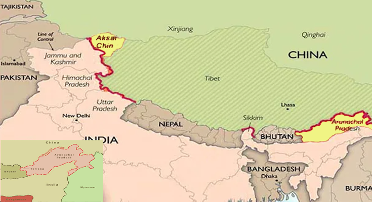
JNS: China’s latest unveiling of its updated “standard map” has ignited a fresh wave of controversy and diplomatic tensions. The map, released on August 28 via the Ministry of Natural Resources’ standard map service website, includes contentious territories such as Arunachal Pradesh, Aksai Chin, Taiwan, and the disputed South China Sea regions.
The map, officially referred to as the 2023 edition, has been presented as an attempt to depict China’s perspective on global geography comprehensively. However, it has drawn swift backlash from neighbouring nations and international observers alike.
The inclusion of Arunachal Pradesh and Aksai Chin has particularly irked India. Both of these regions have been subjects of territorial disputes between China and India for decades. Arunachal Pradesh, located in northeastern India, is claimed by China as part of its southern Tibet region. Aksai Chin, a region located in the western Himalayas, is another contentious area claimed by India as part of its union territory of Ladakh.
Taiwan, which considers itself an independent nation, has also been incorporated into China’s map – a move certain to heighten tensions between the two sides. China has long regarded Taiwan as a renegade province and has not ruled out the use of force to reunify the island with the mainland.
Furthermore, the map’s depiction of the South China Sea has triggered alarm among several Southeast Asian nations with territorial claims in the region. China’s expansive claims over the South China Sea, which conflict with claims from countries like Vietnam, the Philippines, Malaysia, and others, have been a major point of contention and have led to heightened tensions in recent years.
In response to the release, the Chinese state-run newspaper Global Times defended the map, stating, “This map is compiled based on the drawing method of national boundaries of China and various countries in the world.”
The post on the Global Times’ social media account (on X- formerly Twitter) attempted to portray the map as a reflection of China’s interpretation of international boundaries.
The unveiling of this map has the potential to exacerbate already strained diplomatic relations and reignite long-standing disputes. Experts suggest that this move might prompt concerned nations to reevaluate their stances and diplomatic strategies in the face of China’s assertive territorial claims.
Meanwhile, External Affairs Minister Dr S Jaishankar criticised China’s 2023 standard map that claims India’s territory, adding that ludicrous claims do not make other countries’ lands theirs. In an interview with a private channel, Dr Jaishankar said that China often releases similar maps and that including other countries’ territories in its map meant nothing because they are part of India.
Dr Jaishankar stated the Indian government knows how to defend its land.
India has strongly protested the map to China diplomatically. On media enquiries, External Affairs Ministry Spokesperson Arindam Bagchi stated India rejects these charges as unfounded. Such Chinese actions aggravate the boundary dispute, he said.


